You are using an out of date browser. It may not display this or other websites correctly.
You should upgrade or use an alternative browser.
You should upgrade or use an alternative browser.
Bridges - An open thread
- Thread starter Wayne Els
- Start date
 Crossing
- Messages
- 29,864
- Name
- George.
- Edit My Images
- No
Just a simple tourist type Snapograph taken at London UK of the scene from Westminster Bridge looking towards Lambeth Bridge.
RX10M4, 1/1000th @ F4.5, ISO-100, Handheld.
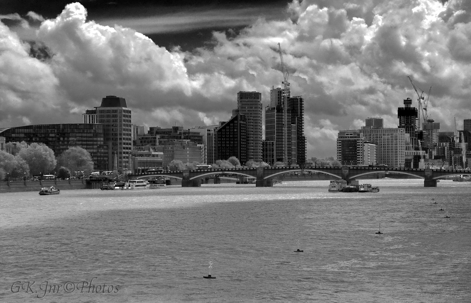 My London (1) (M)-03510M by G.K.Jnr., on Flickr
 for looking.,
 ")
George.
RX10M4, 1/1000th @ F4.5, ISO-100, Handheld.
My London (1) (M)-03510M by G.K.Jnr., on Flickr for looking., George.
- Messages
- 462
- Name
- Dave
- Edit My Images
- Yes
Under the bridges.
I know that there must be an interesting image at this location. Here's my latest try, an image that looks as if it is more than one. I think that the interest helps it to hang together... This is where an old, disused stone and cast iron bridge crosses the canal in parallel with a more modern brick and steel version.
The bridges and locks on the Rochdale canal are numbered. I'd guess that they were numbered before the inclusion of the newer bridge, hence 69a and 69b.
EDIT: I am learning! Apparently, the rail bridges weren't here when the canal was finished. The numbering of the bridges is not quite as I thought. There is a bridge 69, it is a half mile upstream. These later additions, along with almost all the road bridges are numbered in a similar way.
Last edited:
View: https://flic.kr/p/2kHeBDv
first photo on talk photography. Tower Bridge 2016
first photo on talk photography. Tower Bridge 2016
Last edited:
- Messages
- 13,495
- Name
- Immo
- Edit My Images
- Yes
https://flic.kr/s/aHsmUEEkLFfirst photo on talk photography. Tower Bridge 2016
Welcome! Thank you for sharing this nice picture.
- Messages
- 462
- Name
- Dave
- Edit My Images
- Yes
A lockdown walk along a short stretch of the Rochdale canal again today. I was keen to get out to try a new-to-me compact camera.
Apologies for the string of images from the same place. I have to say that I keep discovering viewpoints that interest me.... I must find somewhere else for a walk.
Here's another (third) shot from under the old and the new rail bridges... Good light reflected off the water, couldn't resist it.

Apologies for the string of images from the same place. I have to say that I keep discovering viewpoints that interest me.... I must find somewhere else for a walk.
Here's another (third) shot from under the old and the new rail bridges... Good light reflected off the water, couldn't resist it.


- Messages
- 920
- Name
- Col
- Edit My Images
- Yes
 DSC_4253-Edit by Colin Freeman, on Flickr
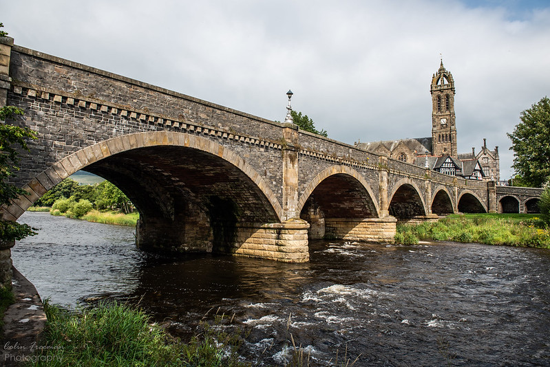 DSC_3994 by Colin Freeman, on Flickr
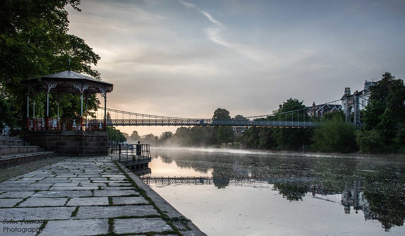 DSC_3545-2 by Colin Freeman, on Flickr
- Messages
- 462
- Name
- Dave
- Edit My Images
- Yes
Another walk, another image to post. A bit further along the Rochdale canal, this time.
Bridge 71 is a lovely cobbled humpback bridge at the end of a lock. To the north, a cobbled lane runs for 150yds to join a country track, to the south side, no clue to what was there or where it went. The bridge is now isolated from any route. I just can't find a nice overall view of the bridge, just these detail shots. I wanted to get the lock gates in more light, so will have to return earlier to catch the sun in the morning.

Bridge 71 is a lovely cobbled humpback bridge at the end of a lock. To the north, a cobbled lane runs for 150yds to join a country track, to the south side, no clue to what was there or where it went. The bridge is now isolated from any route. I just can't find a nice overall view of the bridge, just these detail shots. I wanted to get the lock gates in more light, so will have to return earlier to catch the sun in the morning.


- Messages
- 462
- Name
- Dave
- Edit My Images
- Yes
Nice urban/industria; shot, Immo. I like the plant-life growing from the walls of the canal.
I wondered if they are the same kind of plants that grow in similar places everywhere. On most/all canal walls and stone bridges, there is usually a good selection of plants/trees trying to hold on in the gaps and cracks.
When I looked at my last image, I saw that the plant-life had gone.... I hadn't noticed. A little earlier in the week there was plenty of small plants and several twiggy shrub/trees waiting for spring before the coming into leaf. Now they're gone! The photo below was taken a week ago in the same spot, I wanted to get a better position (to take a photo like my above) but there were several bare branches of a tree that grew out of the wall, in the way and lots of small weeds in the wall of the bridge. Now they're gone.
The canal has been maintained! My images will be poorer for this, I wonder if I should complain?
Last edited:
- Messages
- 9,200
- Edit My Images
- No
Footbridge over the A3052 at Clyst St Mary in Devon...


- Messages
- 462
- Name
- Dave
- Edit My Images
- Yes
Looking at Google maps, it is the Trent and Mersey canal. Here is some info.
Last edited:
- Messages
- 686
- Name
- Iain
- Edit My Images
- No
PS If anybody from the area is viewing this, do you know the name of the waterway. I can't find it anywhere.
Howard,
As cluster has found it is the Trent and Mersey Canal. Big Wood Bridge, as it is called, is between Marbury Contry park and Dairy House Meadows...cross it and keep on a little further for Neumann's Flashes (good for wildfowl). Or a short walk along the canal and you reach Anderton Boat Lift.
Numerous bridges around that area including another almost identical to the one you photographed!
Earlier in the thread you posted a couple of views from Thelwall New Road/Latchford Locks - do you remember roughly when they were taken (clue in the Thelwall Viaduct direction). There are some historically interesting brdge remains beyond the Viaduct.
Just for fun (and as you have also previously posted an Anglesey bridge)...here's a small bridge on Anglesey

Last edited:

Looking at Google maps, it is the Trent and Mersey canal. Here is some info.
Howard,
As cluster has found it is the Trent and Mersey Canal. Big Wood Bridge, as it is called, is between Marbury Contry park and Dairy House Meadows...cross it and keep on a little further for Neumann's Flashes (good for wildfowl). Or a short walk along the canal and you reach Anderton Boat Lift.
Numerous bridges around that area including another almost identical to the one you photographed!
Earlier in the thread you posted a couple of views from Thelwall New Road/Latchford Locks - do you remember roughly when they were taken (clue in the Thelwall Viaduct direction). There are some historically interesting brdge remains beyond the Viaduct.
Just for fun (and as you have also previously posted an Anglesey bridge)...here's a small bridge on Anglesey
View attachment 313607
Thank you both for the information, I must have had a very serious senior citizen moment as I just could not find any name attached to the waterway.
Iiain,
I probably took the shots from Thelwall in the last 10-15 years. As a matter of interest why do you ask? When you say " beyond the Viaduct" do you you mean to the east, ie on the Lymm side? Is there a way of getting closer on that side? Have never ventured down there - only been here 30+ years!!!!
And where is the bridge on Anglesey?
Cheers,
Howard
- Messages
- 686
- Name
- Iain
- Edit My Images
- No
Thank you both for the information, I must have had a very serious senior citizen moment as I just could not find any name attached to the waterway.
Iiain,
I probably took the shots from Thelwall in the last 10-15 years. As a matter of interest why do you ask? When you say " beyond the Viaduct" do you you mean to the east, ie on the Lymm side? Is there a way of getting closer on that side? Have never ventured down there - only been here 30+ years!!!!
And where is the bridge on Anglesey?
Cheers,
Howard
I was just wondering as I thought the viaduct direction only showed one (maybe mistaken, I should go back through the thread sometime).
First (closest to Latchford) one was opened in 1963 - the pillars either side of the canal being hollow and accessible from the catwalk** when I was a teenager, second built in the early 90's?
As for the interesting (such things are relative of course but I love IA) remains, yes, Rixton Moss side (specifically, to the defunct Statham Lane side where the Murkey Way walk now runs.....and that's a very big clue to the what and the why). Large sections of the canalsides can be explored with careful planning. Back on the Statham side of the ship canal there are the concrete barges down the appendix like piece of the old River Murkey though probably totally overgrown in the 40 years since I last looked at them. It's a shame Pool Bank Farm has gone...lovely building but very damp and of no interest the National Tax Dogers Trust. If you like milk there is a farm close by that supplies fresh milk in these strange one pint glass containers with foil on the top
Bridge on Anglesey was a phone grab when out hunting for a limekiln near Wylfa.
...and better add a photo as that's what the thread is for...this little beauty is in Wales and I pass it often. Time has removed any clue as to why it's built there...the track to it clearly went from the road I'm on but there has never been anything significant on the other side and there's a more sensible way to get to the other side without crossing the stream there!

One day I'll make time to stop and take better photos
**I know nothing about any empty beer cans or furniture that may have been found in there when they sealed the access in the 1990s
Last edited:

D
Deleted member 89409
Guest
Bridge 142 on Shropshire union - ellesmere port. Just by garage where I get my MOT - an hour out of the house during lockdown whoopee !


 Bridge of Alvah 0916
- Messages
- 4,266
- Name
- Rick
- Edit My Images
- No
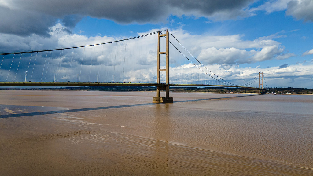 DJI_0013-Edit.jpg
- Messages
- 686
- Name
- Iain
- Edit My Images
- No
Ditchfield Bridge taking the A56 over the Bridgewater Canal at Lymm, Cheshire
Apparently rebuilt in 1926.
Though officially "Ditchfield's Bridge" I have never heard a single person use that as a name for it...always Camsley Lane Bridge.
I remember the canal having a slight rupture just behind where you are standing to take that photo.
It's one of the few bridges that has still got it's crane and stoplogs (New Lane Bridge in the town centre had one when I was a nipper and I've often wondered if it was removed to make the picture postcard view of Canalside Cottages and the bridge better)..
And as usual, can't just add waffle so here is another bridge, or at least a piece of one, on the canal which still has it's crane and stoplogs.
Agden Bridge

And as a bonus ....Howard has previously posted a part of this where is crosses a road but it's really Whitbarrow Aquaduct. It crosses Slitten Brook before crossing Whitbarrow Road....though you can't really see either from this vantage point unless you know it's there.
It was a grabbed phone shot after we pushed off the bank having stopped to replenish the tankards. Spey is a wooden-hulled tar carrier with a wonderful Bolinder hot bulb engine so I make no excuses for the photo

Last edited:
- Messages
- 686
- Name
- Iain
- Edit My Images
- No
Thanks Iain, once again, for all that history. I took the name of the bridge from the parapet, coming on here one doesn't half learn a lot!!
I remember Wallyton Borough Council putting signs up at the end of The Avenue which said 'Crossfields Bridge' ....bearing in mind that Joseph Crosfield estabnlished his soapworks/chemical factory in Wallyton (and paid half the cost of their town hall) you'd think they could have got the spelling correct (I think it is now). An interesting re-inforced concrete bridge built by Fairclough Brothers for Lord Lever and CG Dewhurst (one of the main beneficiaries of Lymm Grammar School) it is unfortunately in a very poor state with serious spalling. The reason for it and some of the other features (including two bridges) around the upper two dams at Lymm are interesting. There's another interesting bridge, Scholar's Bridge (though it's not in the same place now as it was 50 years ago) at the top of The Bongs....but all this is straying just a little bit too far!
Granthams Bridge has a name plate and other interesting signs including old cast iron weight limit ones. Design is the same as most of Brindley's others along the canal. I have photos but am going to a different area for todays addition.
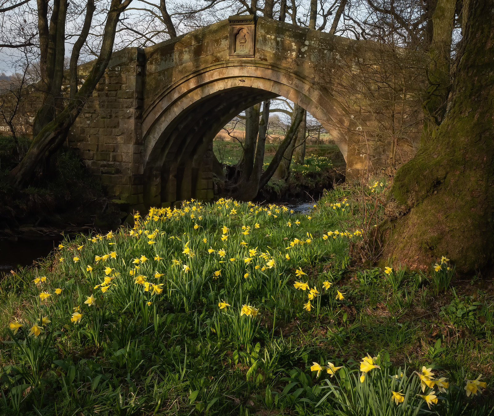
Out in Yorkshire surveying some kilns yesterday and there were plenty of bridges to choose from. This one amused me as the bridge looks fairly new but the small ghyll it crosses obviously wasn't so keen and now goes either side of it.

Last edited:
- Messages
- 9,200
- Edit My Images
- No
Footbridge at Swindon Station...


- Messages
- 762
- Name
- Paul
- Edit My Images
- No
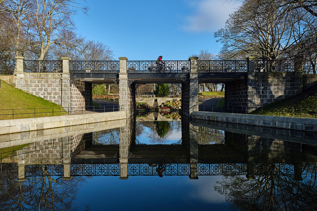
 Pitfour Lake, Mintlaw, Scotland
- Messages
- 3,170
- Name
- North York Moors
- Edit My Images
- Yes