Named Storms

Messages
12,139
Name
John
Edit My Images
Yes
Looks like storm Austen is battering the south/south west with power outages across Cornwall. The Met Office said it had developed into a "weather bomb" as it approached the south west. From the Met Office.:: “Storm Austen will rapidly deepen as it approaches the UK, undergoing a process known as explosive cyclogenesis. Its central pressure is expected to fall by at least 24 hectopascals in 24 hours, making it what’s sometimes called a ‘weather bomb’. The central part of the Jet Stream was moving at 200mph. The norm over the UK is 120mph.

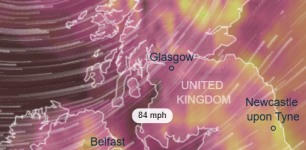
Last year we had storm Amy..October 3rd followed by storm Benjamin on the 22nd 22/23 . First and second storms of the season..so three weeks between but on Saturday Scotland,NI and parts of northern England will be battered by the second storm of the season...Boelo.. with an even lower central pressure than Austen which is/was about 970/980 hPa/mbs. Some forecasters have put it as low as 940/950. That will do some severe damage featuring amongst our worst storms just over the past three years. One bad one was also called Amy which hit Scotland on October 1st last year at 942hPa/mbs lowest pressure with the central part at 950 hPa/mbs .

Storm Austen has caused a number of schools to be closed in the impacted areas with many others opening later than usual to avoid the strongest winds.Train cancellations and speed restrictions are in force because of the increased danger of branches and trees blocking railways. A number of ferry sailings have also been cancelled, including crossings between Pembrokeshire and Ireland.

This is Mullion Cove which is about 3 miles from Lizard and high tide was 3.30am. Now 9.50 as I post but it's still very rough.Just scroll down below the header photo taken from the Mullion Cove Hotel where I've taken some lovely photos over the years in the very same spot to the west side of the hotel overlooking the cove..The webcam is located there.
 
Last edited:
Plummeted to about 975(mbar) 18 hours or so ago but bouncing up a bit now, rather slower than the drop!
 
We are anticipating the effects of the next one, Beolo, I've set the solar to Power Cut mode so that my batteries will be fully charged if power goes down (to enable us to run one of the fridge/freezers off battery), and we've just done our weekly shopping with a little more gusto. Hopefully our trees will be ok, but I'm sanguine about it - I can always plant more.
 
We are anticipating the effects of the next one, Beolo, I've set the solar to Power Cut mode so that my batteries will be fully charged if power goes down (to enable us to run one of the fridge/freezers off battery), and we've just done our weekly shopping with a little more gusto. Hopefully our trees will be ok, but I'm sanguine about it - I can always plant more.
That's an apt term,Lindsay..doing your shopping with 'a little more gusto' .Gustos is what you'll get tomorrow at about 75-80mph around you neck of the woods but more on the coast. The pressure is still forecast to be 950 mbs. .My word..that's low. And...mid-week to the end of next week there's a chance of yet another named storm. I think El Niño is doing its worst.

Btw...Boelo was named by the Dutch weather service, KNM, which works with our Met Office along with Met Éiriann (Ireland) The name Boelo (pronounced Boo-Lo) was submitted to them by a Dutch family who had that name passed down their generations.
 
75-80mph - bah! that's nowt...it's similar to several last winter. It is a bit scary. We are close to but not actually on the coast, and we are up a rise but still only 23m asl. Unlikely to suffer flooding as there are lower fields all around, but the wind has taken down a few trees in the past and our electricity comes to us overhead on wooden poles across a field near trees, and we are the only house on that wire. We have resilience preparations though.
 
75-80mph - bah! that's nowt...it's similar to several last winter. It is a bit scary. We are close to but not actually on the coast, and we are up a rise but still only 23m asl. Unlikely to suffer flooding as there are lower fields all around, but the wind has taken down a few trees in the past and our electricity comes to us overhead on wooden poles across a field near trees, and we are the only house on that wire. We have resilience preparations though.
Lol.. I like your stoicism. I do think this one's going to be pretty bad. At least no flooding. It's heart-breaking to see TV reports of peoples' kitchens and living rooms under dirty flood water. I think you might lose some trees ,though. Hopefully, the electricity poles will withstand it all. Down here, I think we'll just get heavy rain..not so much strong winds. I see the warnings for you start at 10.00am.
 
No real problems around here, although the post office claim that they couldn't get here... Funny how busses, normal people and other delivery services managed!
 
The annoying thing for me at this point is that I was planning to drive over to Carrivckfergus early tomorrow to attend a ham radio event, but it's a two hour drive each way and coming back might be a bit hairy in the mid afternoon. I don't want to cry off, but I think caution may be the better part of valour, or something like that. I'm in Limavady the following Saturday which is the same side of the country (sort of) from where I am, so that's my mitigation. Hmmm.
 
They closed the forest by me yesterday (Wyre Forest) because of the danger of trees falling on your head.

We had just a strong breeze and a fair amount of rain so it didn't really need to be closed after all. It was still being patrolled (5 car parking areas in 13 sq miles) by wardens to keep people out though.

Lucky a leaf never got to fall on someones head then!
 
The annoying thing for me at this point is that I was planning to drive over to Carrivckfergus early tomorrow to attend a ham radio event, but it's a two hour drive each way and coming back might be a bit hairy in the mid afternoon. I don't want to cry off, but I think caution may be the better part of valour, or something like that. I'm in Limavady the following Saturday which is the same side of the country (sort of) from where I am, so that's my mitigation. Hmmm.


Probably too late now but maybe make a night away out of it? Take Mrs P(?) with you and stay over tonight.
 
@Nod too late certainly, but not an option for us both to stay overnight anyway - 2 dogs and 5 cats to take care of, including one on medication. Not a problem though, I just checked the forecast again early this morning and decided "Nah!" so we've just been out for a nibce Ulster fry and are now hunkering down for the duration. I ought to go down to the beach will]th a camera later but suspect I'll prefer to stay in the warm and dry - not a very dedicated tog!
 
The beach would be a good shout, even sans camera! As long as you can stay safe on it.

I LOVE stormy beaches and the Moor, mainly because I don't often have to share them with too many people.
 
In my part of norf wales it’s giving a sunny day but with 59-60 mph winds , so might just go for a snoop round the local berry bushes and see if any winter thrushes have arrived yet , the big tides aren’t due till mid week so not much point in going down to the sea / estuary , but I’ll be keeping a watch on birdguides etc for storm bird sightings
 
This morning:

PXL_20261024_065742365.jpg


Now: :oops: :$

1792876967993.png
 
It was a bit hairy last night, it got worse around midnight, but it's still been gusty this morning (up to 60kn). It was a a very cold wind too, down on the beach walking the dogs. We screwed up on the clocks too, getting up at what was really 3:30am instead of 4:30 because we forgot the clocks were changing.
 
we forgot the clocks were changing.


:LOL:

I even posted

ac26c3147aa0ba043f8effdcec327331b87dfda9_2_753x748.jpeg

yesterday to remind everyone!

Half of my clocks and watches are either radio controlled or set to Greek Summer time but I still have a few to do!
 
:LOL:

I even posted

View attachment 495826

yesterday to remind everyone!

Half of my clocks and watches are either radio controlled or set to Greek Summer time but I still have a few to do!
Yup, distributing the news I see........ eh!;)
 
Pointless these days...
 
We missed it all bar some short-lived heavy rain and a bit blustery. Austen was too far south and the strongest winds are on the south of a storm so I'm gues sing northern France was hit and Boelo was off the top of Scotland way off. It's like a lottery. For the SSW Midlands the centre of a Low would have to be in the region of Liverpool.The Met Office people are forecasting that another deep Low will hit us tomorrow into Tuesday out of the south west. Dependinbg on how. it shapes up it might become named storm three..Chloe. It's on track for NW Ireland and Scotland. Almost the same track as Boelo.

Current radar. Good grief. The system stretches from Florida to Ireland. There's an animation button at the bottom.

 
Back
Top